
|
This has definitely been the most active Spring for convective activity for many years with numerous outlooks issued, surprisingly high caliber parameters, and now the highest CAPE values of the season, and it's still early days yet. Since my last update I've undertaken perhaps half a dozen local chases, some where busts, others produced however the set-up never yielded any photo opportunities so the chase continued. Events of note where the hail core at Co. Armagh which filled the roof tops and gutters with so much hail that it almost looked like snow, then from the same location Roisin and I heard our first thunder of the season, although it was a few miles away from our location that was the season broke in.
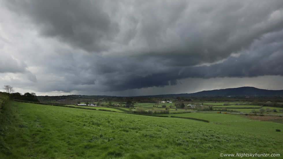
April 14th was a low risk set-up with 200-300 j/kg of CAPE however there was no wind shear so any storms would be of the pulse variety, there was little wind despite a NWly flow and a convergence zone near Lough Neagh so funnels were possible, this alone justified a local chase. Based on the AROME I decided to target Lough Neagh where I met up with chasers John Fagan and Colleen Webb. There were good sunny spells and convection was growing however it was evident from the onset that the tops were capped by an inversion and wouldn't reach the height they needed to be for electrification, despite feeling disappointed we remained faithful to the location and stuck it out.
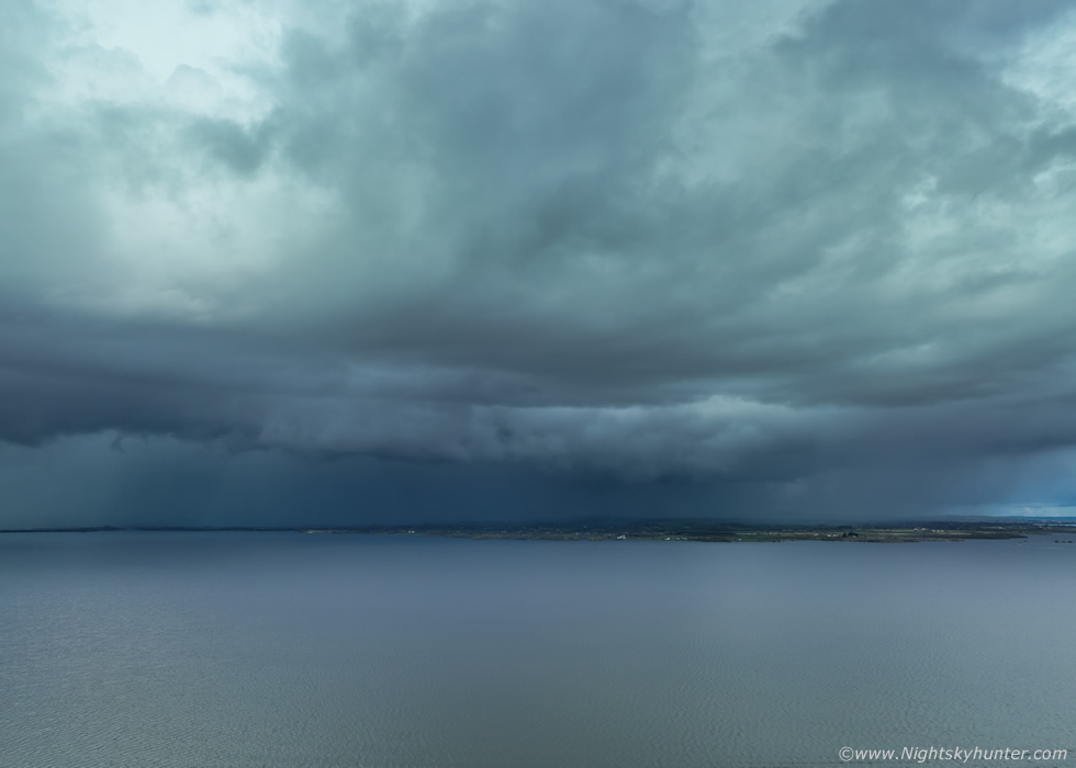 |
Our patience was rewarded when a cell formed to the N then trekked slowly SE across the northern portion of the lough. It really tried, the sky grew dark and curtains of precip began to fall over the water then the cell formed a nice little shelf cloud along it's leading edge. John was shooting DSLR images while Colleen and I got our drones in the air, I was shooting stills and video with the DJI Mavic 3 Classic, a drone which I'm still pressure testing and putting through its paces. Despite being a rather weak shelf cloud it actually looked decent enough given the set-up and to be honest we were all surprised to see what became the main structure of the day, at this time there was a good fall of hail over Toome and Staffordstown, classic April showers.
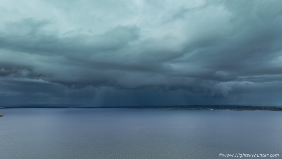 |
It evolved into a fairly nice structure before this section moved away to the right over the Antrim side of the lough. This line was growing and now stretched from the lough and across land to our W and it was this area which was now intensifying as it moved toward our position. We were astonished to witness an impressive rotation event along the leading edge, strong rotation combined with vertical motion at the same time, this rotation lasted for 15 min's as we watched with great anticipation in the hope that a funnel would form. It never did, but it didn't matter, the rotation was impressive enough and again more than we had expected to see this day. The cell dumped torrential rainfall then another good hail storm, Colleen and I stood outside in the deluge getting soaked to the skin, we just wanted to experience the core. Not at a bad day at all, a shelf, rotation and hail. By late afternoon we called an end to the chase as the CAPE began to wane. Had this day not been capped we were certain this would have been a good thunderstorm.
 |
Following the unstable weather we ended up having a few days of high pressure which actually brought a period of lovely weather, it was mild, dry, and the wind was light. The hazy sky which accompanies HP always produces a good sunset show, the thicker haze acts like a filter dimming the intensity of the sun allowing for the solar disk to appear with the naked eye with great photo potential. I decided to make the most of it and spent two evenings shooting the sunset. On April 18th I teamed up with John Fagan at Beaghmore on a lovely mild evening, we where located on high ground with a terrific view of the W sky. We observed a good sunset and both got nice disk shots, then we relocated to the stone circles and met Colleen Webb. We observed Venus and a very nice sunset afterglow. There was a chance of aurora so we waited until darkness, the Bz shot back N which killed any good geomagnetic storm however we did pick up a faint aurora on camera which wasn't visible with the naked eye.
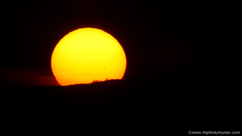
The next day I accidentally formatted my memory card and lost all my sunset images from the night before, I was so annoyed with myself. I decided I would try again this night, April 19th. My dog Rhua and I went to a good vantage point above Moneymore, the camera with 100-400mm was tripod mounted and we just waited as the sun lazily sank towards the horizon. The air was mild, still, the midgets danced in the air, the sky was cleaner this night so I really had to stop down the aperture and use a fast shutter speed to get the disk, but once on the horizon I got the shot I wanted. You can even see a large sunspot group, incidentally that group would unfurl a fast moving CME soon after this which hit the Earth two nights later producing the strongest geomagnetic storm since the last solar cycle with an overhead corona, flashing and pulsating forms, huge beams, and was rated as a G4 but so strong it came close to G5. Of course we missed the entire show due to clouds.
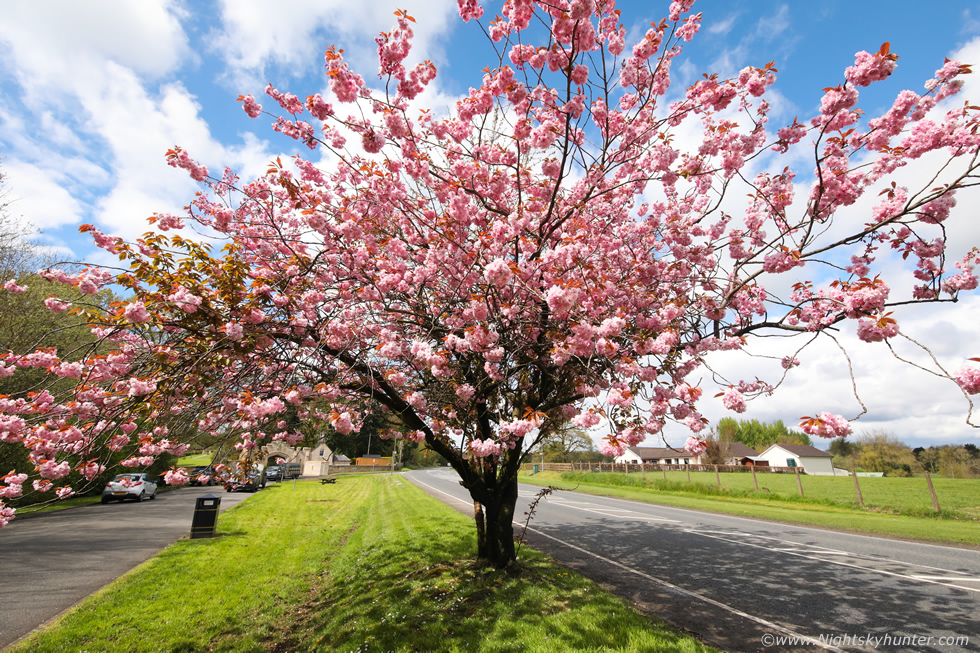 |
April 28th was a 500 CAPE slack flow day with no shear, however once again funnels were possible in such scenarios so I was back out chasing again. The dreaded cap once again kept the atmospheric lid on the towers however the sky was still talking, with good solar heating it looked like a nice day to be out. I ended up spending five hours on the hunt, I simply had to stop to take an image of this Cherry Blossom on the Omagh Road, these trees always remind me of storm season and bring back happy memories of excited chases from many years ago.
I ended up back at Beaghmore, to cut a long story short I watched a cell form under the inversion which developed a dark high large textured base which slowly hung over the hills. I chased it over the scenic route - a great area for chasing by the way - and followed it back to Cookstown. From Glenavon Hotel car park I watched the base for another half hour as it slowly lifted and rotated with scud teasing me with the prospect of a funnel. It migrated SE of town so I went after it and ended up stuck in traffic, my route was blocked by police and fire trucks, I found out later that a lorry had caught fire so the road was closed. That ended my chase, I enjoyed the base from Killymoon then returned home, even though I had no images worth posting I still really enjoyed the day.
April 29th was another chase day, 700j/kg of CAPE, SWly flow, -20c tops, light winds at surface but no shear. Given the decent CAPE and convergence big pulse storms were possible. I targeted Co. Tyrone and ended up spending seven hours on the road, most of that time waiting on road sides watching convection. I got a cell at Dungannon then took the carriageway to Omagh, while driving beautiful sunlit towers were going up everywhere, things looked promising indeed. I went through Beragh to Mountfield then met Paul Martin near the Seven Sisters where we spent the rest of the day. Convection tried however yet again the towers were capped, we couldn't believe it, however we did experience overhead rotation in the form of a cinnamon swirl which was quite cool to watch. We flew the drones and had a good time and at times the capped convection was nice to see.
Deep down I was annoyed as I had yet to catch anything decent on camera, in fact, I had only taken two images with the DSLR and these were deleted. My desire to capture something cool was burning strong and I was beginning to feel 'the heat'. I was home for 18.30 then Roisin and I went out for dinner, when I came home after 20.00 I learned of a big thunderstorm over Derry/Londonderry with produced a lot of lightning, I was shocked, I never expected that area to produce so far N, however there was good convergence there. I was gutted to have missed it however the few images I saw online of the storm made me feel better, it wasn't photogenic so I let it go, after all, I had one last chance the following day.
April 30th was my last chance to catch something cool before the pattern changed. This day would bring the highest instability of the year with more than 1000j/kg of CAPE, LIs -3 and a Sly flow with -50c cloud tops. The soundings showed less capping than the previous day and higher towers getting more than 25,000ft. There was no shear so it would be a day of pulse storms, however the slack winds, surface convergence and big energy had the potential to produce short-lived but intense cells with a high prospect of funnel clouds. The Met Office had issued their first thunderstorm warning of the season and CW even issued an amber box within their slight risk zone for N and NE N. Ireland. Things were looking good, CAPE and flow and coldest upper air all seemed to favour the midlands then Co. Antrim and Co. Down as the main target areas into the evening. The AROME indicated Tyrone and Antrim as the hot spots but also strong convergence along the E coast over the sea. I was seriously tempted to head straight there incase of waterspouts but decided to hold back.
My plan was to head to Maghera as a base and from there target Ballymena or Portglenone then chase over the Antrim hills to the east coast if necessary. That morning was bright and sunny with blue skies and great eating, even at 9am I was seeing towers building, the sky was talking already and I got a feeling this was going to be a good day. Roisin, Rhua and I were going to make a day of it and planned to chase until evening, I was determined to get something decent on camera. We packed snacks, water, a flask and clothes then hit the road. By 11am towers were going up everywhere in all directions, it was difficult to not get excited, radar showed cells with red cores already over Co. Tyrone moving up so everything was looking great.
After a couple of hours of sitting on back roads my mood began to dip, the convection was getting messy and the towers still looked capped, also the radar was a mess too, it seemed there were so many showers forming that they were getting in each other's way, this is what happens when you have no shear. I feared the day was going to be another let down but tried to remain upbeat. Roisin and I had lunch in Maghera then hit Glenshane then we ended up in Gulladuff. I spotted a huge anvil to my SW, the best thing we had seen all day, at last we had a target. I received phone calls from John Fagan and Nigel McFarland who were also chasing, I was informed that anvil I was watching was already sparking over Ballygawley, in fact, Roisin and I could faintly hear distant rumbles, at last a storm!
 |
We chased SW to intercept this storm, I pulled over at an old favourite spot at Knockloughrim overlooking the Sperrins. This was the storm base under that big anvil. It was moving NE and starting to pick up speed, that dark region is a new base. We watched for a while then decided to get closer, I wanted to see if that dark area looked better up close for structure and also wanted to sample the core for some excitement. I raced off along the Glenshane Rd, then through Magherafelt to the outside of town, but the cell was on us fast and we ended up in the core.
We pulled into TESCOs and watched the rain, then flash!!! and loud thunder!!, this was our first close range thunder of the season, and it shifted our moods to an elevated level, we were back in the zone again. I got a call from Nigel, he was watching the same cell from Glenshane and saw the bolt itself in the form of a beautiful c-g. Then another flash and more thunder, it looked like nature was finally rewarding us. Nigel informed us that another cell was approaching the area behind this storm so we decided to make our play on that one, this time we would get ahead of it and watch it coming. Roisin's instincts suggested Ballyronan Marina so we parked there and waited.
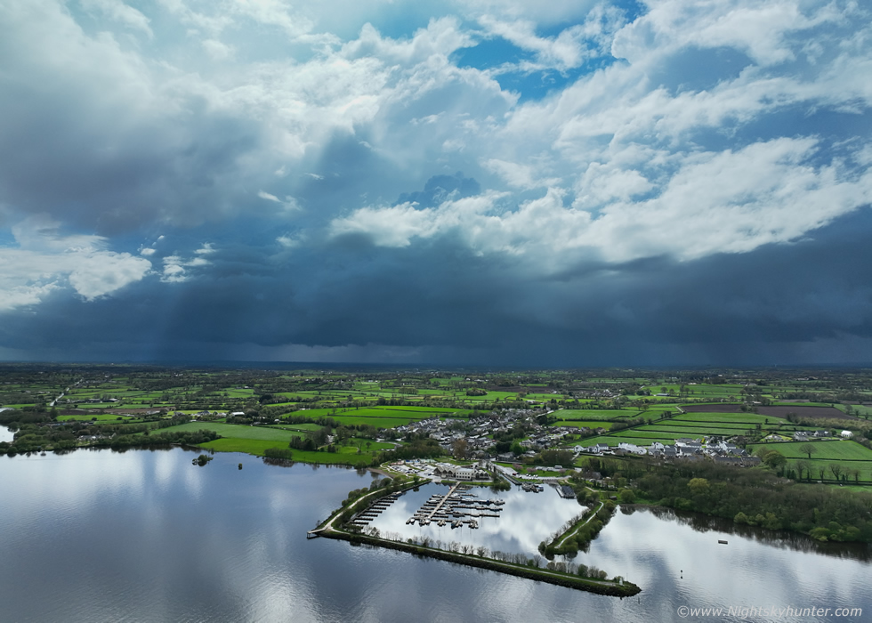 |
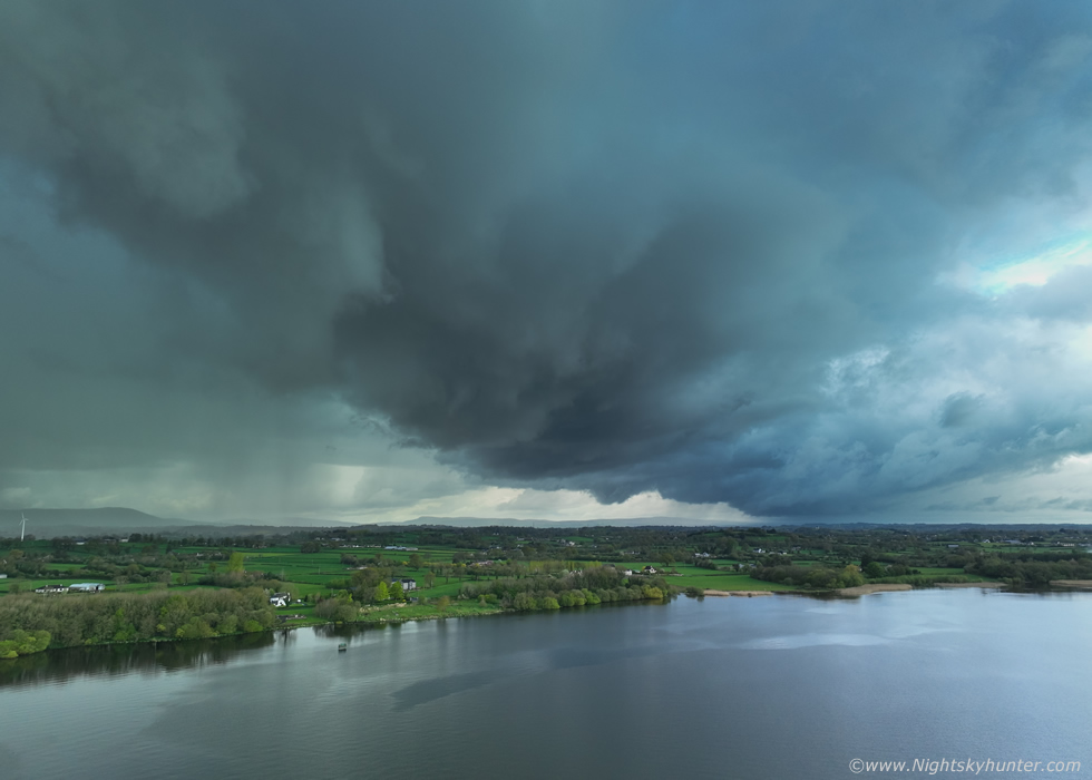
The sun was shinning and the Marina was in fine form with families enjoying their day out. However there was trouble brewing a few miles away, behind the tree tops I could see dark skies and big billowing towers sharp against the skyline, this was the next cell approaching, I said to Roisin this was going to be our next thunderstorm. Our view of the horizon was blocked by trees and other obstructions so I launched the Mavic 3 Classic into the air, climbed to 80m altitude, then flew out over the lough, panned the drone around to face towards the W, and there was our first view of the next cell. This was a line or cluster of cells with several nice white updraught towers catching the sun while below a very dark base extended across the sky and it had that thundery blue look.
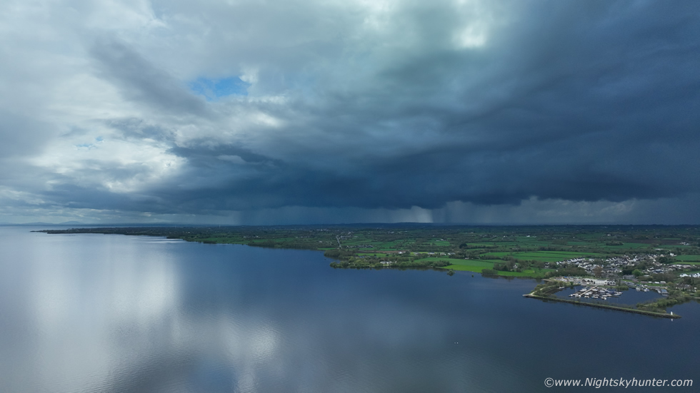 |
Panning the done to the left towards the SW sector of Lough Neagh to reveal the S end of the cluster, a nice compact shelf cloud was already present. John Fagan rang me, I let the drone hover while watching the screen and listening to John, he was getting a storm near Dungannon and now Coalisland was getting many rumbles of thunder, that shelf to the left on the image was the Coalisland storm.
 |
15 min's later the N section of the cluster rapidly developed and formed into a chunky gust front approaching Ballyronan. This moment made my day, this was my first proper storm structure of the season, I couldn't believe how fast the base had transitioned from an ill-defined form into this beast within minutes. This image is using the full size of the four thirds sensor, I was delighted with the structure, I showed Roisin on the screen and she was delighted too, both of us were relieved that finally we were seeing something dramatic.
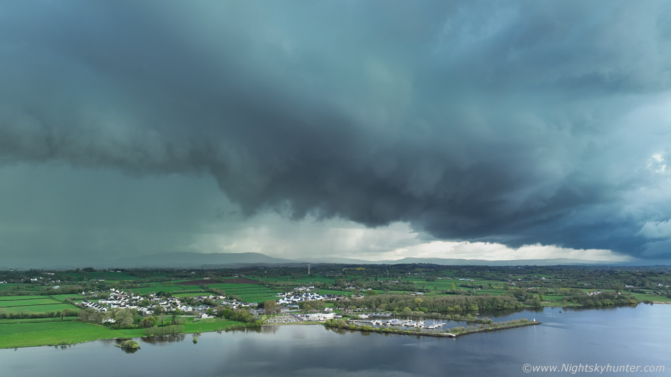 |
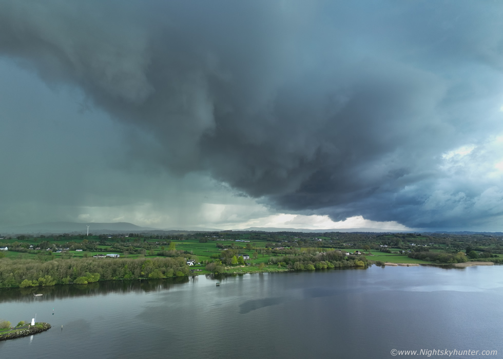
Another image at 16x9 crop with a pronounced wedge-shaped scudy lowering along the guster, these scud 'teeth' are a classic feature of shelf clouds. Check out how much the storm dwarfs Ballyronan town and marina. I consider a drone to be a superb piece of equipment for the storm chaser, if I look back on how many chases over the years which ended in disappointment because a cool scene was ruined by power lines, houses, trees etc blocking the view, now I can just send the drone up to avoid any obstructions and get the perfect view of the entire storm to the horizon.
 |
The N section of the guster is almost filling the wide angle field of the M3C's camera, this was a lot closer than it looks here, the wide FOV gives the impression it was someway off, but it wasn't, it was rite beside our location on shore, the precip core was only a mile or so away.
 |
I stayed in the air as long as I could getting as many stills and footage as I could without putting the drone at risk
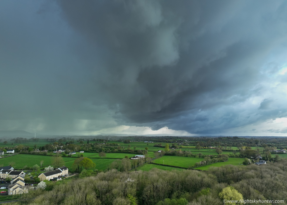 |
I had already flown back to shore and hovered over the trees for this final image of the guster surging across the landscape. I looked away from the controller and up and all I could see was this huge silver-grey wall of precip about to hit. I landed the drone with seconds to spare just as the first rain drops began to fall. My last sight was a casual glance of the beautiful pink Cherry Blossom trees which lined the marina and these nasty storm clouds lurking overhead like an atmospheric monster. Roisin shot several snaps with her phone then we jumped back in the van for shelter just as the core hit full-on.
The core was torrential rain and the outlflow wind was blowing the rain horizontal, several walkers and joggers were completely caught off guard as it appeared to simply come from nowhere - if you didn't know how to read the sky that is - and many ran for cover. Then the precip lit up twice with bright blue flashes of lightning which seemed to be either embedded within the core or high up in the tower, two loud satisfying cracks of thunder followed which were the icing on the cake.
Once it passed we began our drive home, we where shocked to see the roads covered in stones, gravel and debris washed down from the hills by the storm, the roads were covered all the way from Ballyronan to Moneymore, even the drain covers were vertical pointing skywards, the water must have overwhelmed the system. Locals agreed it was a mean storm, and according to my records it was the best storm in this region for the month of April since 2009. In fact, CW have already issued statistics that UK and Ireland has already had its best convective activity since 2019 with storm rates higher than recent years, long may the trend continue.
Drone footage of the approaching gust front at Ballyrona Marina, Roisin had phone footage of the thunder however I didn't include it as this was mostly thunder and heavy rain. This was a nice little storm and a rewarding roller coaster of a chase day which brought my first decent structure of the season so I went home content to say the least. I've a feeling we could be in for a record storm season so long may it continue. Thanks very much for reading.
Martin McKenna
